


Touligny Raillicourt Barbaise

Superpape
User
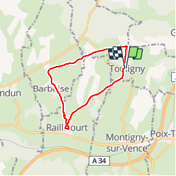

Length
9.8 km

Max alt
275 m

Uphill gradient
151 m
Km-Effort
11.8 km

Min alt
188 m

Downhill gradient
148 m
Boucle
Yes
Creation date :
2019-03-12 12:03:24.753
Updated on :
2019-03-12 12:03:24.781
2h34
Difficulty : Unknown

FREE GPS app for hiking
 SityTrail
IGN / Geographical institutes
SityTrail Plus
The world is yours!
About
Trail Walking of 9.8 km to be discovered at Grand Est, Ardennes, Touligny. This trail is proposed by Superpape.
Positioning
Country:
France
Region :
Grand Est
Department/Province :
Ardennes
Municipality :
Touligny
Location:
Unknown
Start:(Dec)
Start:(UTM)
616593 ; 5503261 (31U) N.
Comments