


Wikiloc - Trace rando Brayonne du 6 octobre

olivieraron
User
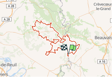

Length
168 km

Max alt
245 m

Uphill gradient
2309 m
Km-Effort
199 km

Min alt
54 m

Downhill gradient
2303 m
Boucle
No
Creation date :
2023-01-03 04:17:37.603
Updated on :
2023-01-03 04:19:31.193
5h00
Difficulty : Difficult

FREE GPS app for hiking
 SityTrail
IGN / Geographical institutes
SityTrail Plus
The world is yours!
About
Trail Moto cross of 168 km to be discovered at Hauts-de-France, Oise, Sérifontaine. This trail is proposed by olivieraron.
Positioning
Country:
France
Region :
Hauts-de-France
Department/Province :
Oise
Municipality :
Sérifontaine
Location:
Unknown
Start:(Dec)
Start:(UTM)
411048 ; 5465081 (31U) N.
Comments