


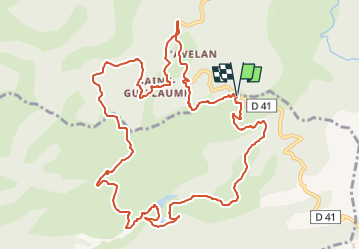
SityTrail - chapelle st guillaume

affinetataille
User GUIDE

Length
14.1 km

Max alt
461 m

Uphill gradient
565 m
Km-Effort
22 km

Min alt
115 m

Downhill gradient
571 m
Boucle
Yes
Creation date :
2023-01-03 15:34:28.671
Updated on :
2023-05-08 09:50:21.357
6h00
Difficulty : Difficult

FREE GPS app for hiking
 SityTrail
IGN / Geographical institutes
SityTrail Plus
The world is yours!
About
Trail Walking of 14.1 km to be discovered at Provence-Alpes-Côte d'Azur, Var, Collobrières. This trail is proposed by affinetataille.
Description
départ col de babaou
Photos


29 photos in total. Please click on a photo to see them all in the gallery.
Positioning
Country:
France
Region :
Provence-Alpes-Côte d'Azur
Department/Province :
Var
Municipality :
Collobrières
Location:
Unknown
Start:(Dec)
Start:(UTM)
280975 ; 4787018 (32T) N.
Comments