


Chartreuse le Sapey

c.gourme
User
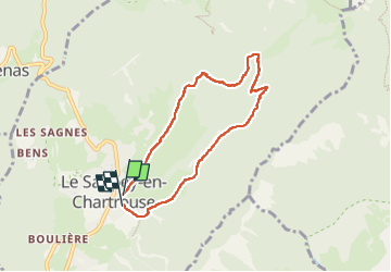

Length
6.9 km

Max alt
1285 m

Uphill gradient
318 m
Km-Effort
11.2 km

Min alt
992 m

Downhill gradient
332 m
Boucle
Yes
Creation date :
2022-12-17 08:26:33.0
Updated on :
2023-01-03 22:19:50.066
2h34
Difficulty : Easy

FREE GPS app for hiking
 SityTrail
IGN / Geographical institutes
SityTrail Plus
The world is yours!
About
Trail Walking of 6.9 km to be discovered at Auvergne-Rhône-Alpes, Isère, Le Sappey-en-Chartreuse. This trail is proposed by c.gourme.
Positioning
Country:
France
Region :
Auvergne-Rhône-Alpes
Department/Province :
Isère
Municipality :
Le Sappey-en-Chartreuse
Location:
Unknown
Start:(Dec)
Start:(UTM)
718021 ; 5015548 (31T) N.
Comments