


Lagorce ouest

pb07
User
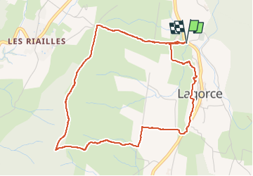

Length
5.2 km

Max alt
335 m

Uphill gradient
209 m
Km-Effort
8 km

Min alt
158 m

Downhill gradient
209 m
Boucle
Yes
Creation date :
2023-01-04 13:23:53.663
Updated on :
2023-01-04 15:23:35.598
1h59
Difficulty : Medium

FREE GPS app for hiking
 SityTrail
IGN / Geographical institutes
SityTrail Plus
The world is yours!
About
Trail Walking of 5.2 km to be discovered at Auvergne-Rhône-Alpes, Ardèche, Lagorce. This trail is proposed by pb07.
Positioning
Country:
France
Region :
Auvergne-Rhône-Alpes
Department/Province :
Ardèche
Municipality :
Lagorce
Location:
Unknown
Start:(Dec)
Start:(UTM)
612639 ; 4923096 (31T) N.
Comments