


13 Vitrolles Arbois Château eau

Nathy8913
User
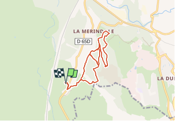

Length
8.4 km

Max alt
169 m

Uphill gradient
147 m
Km-Effort
10.3 km

Min alt
112 m

Downhill gradient
147 m
Boucle
Yes
Creation date :
2023-01-04 16:59:54.369
Updated on :
2023-01-04 17:01:21.537
2h20
Difficulty : Easy

FREE GPS app for hiking
 SityTrail
IGN / Geographical institutes
SityTrail Plus
The world is yours!
About
Trail Walking of 8.4 km to be discovered at Provence-Alpes-Côte d'Azur, Bouches-du-Rhône, Aix-en-Provence. This trail is proposed by Nathy8913.
Positioning
Country:
France
Region :
Provence-Alpes-Côte d'Azur
Department/Province :
Bouches-du-Rhône
Municipality :
Aix-en-Provence
Location:
Unknown
Start:(Dec)
Start:(UTM)
687387 ; 4817671 (31T) N.
Comments