


2023 Galette

sylbois
User
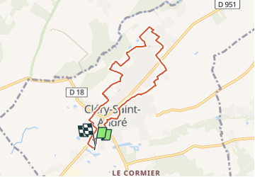

Length
7.3 km

Max alt
100 m

Uphill gradient
37 m
Km-Effort
7.8 km

Min alt
87 m

Downhill gradient
36 m
Boucle
Yes
Creation date :
2023-01-04 17:09:34.969
Updated on :
2023-01-04 17:10:38.274
1h46
Difficulty : Medium

FREE GPS app for hiking
 SityTrail
IGN / Geographical institutes
SityTrail Plus
The world is yours!
About
Trail Walking of 7.3 km to be discovered at Centre-Loire Valley, Loiret, Cléry-Saint-André. This trail is proposed by sylbois.
Positioning
Country:
France
Region :
Centre-Loire Valley
Department/Province :
Loiret
Municipality :
Cléry-Saint-André
Location:
Unknown
Start:(Dec)
Start:(UTM)
406634 ; 5296562 (31T) N.
Comments