


tour de Conlie

xst
User
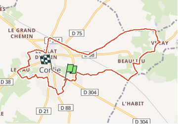

Length
11.5 km

Max alt
172 m

Uphill gradient
121 m
Km-Effort
13.2 km

Min alt
106 m

Downhill gradient
127 m
Boucle
No
Creation date :
2023-01-05 13:16:34.899
Updated on :
2023-01-05 15:23:46.799
2h02
Difficulty : Easy

FREE GPS app for hiking
 SityTrail
IGN / Geographical institutes
SityTrail Plus
The world is yours!
About
Trail Walking of 11.5 km to be discovered at Pays de la Loire, Sarthe, Conlie. This trail is proposed by xst.
Description
départ du prking de SuperU.
Positioning
Country:
France
Region :
Pays de la Loire
Department/Province :
Sarthe
Municipality :
Conlie
Location:
Unknown
Start:(Dec)
Start:(UTM)
722400 ; 5333898 (30U) N.
Comments