Trail Walking Plougonvelin - PLOUGONVELIN - Photo
© OpenStreetMap contributors
Length
Length
12.2 km
Max alt
Max alt
47 m
Uphill gradient
Uphill gradient
146 m
Km-Effort
Km-Effort  
14.1 km
Min alt
Min alt
0 m
Downhill gradient
Downhill gradient
149 m
Boucle
Boucle
Yes
Creation date :
2018-09-01 15:24:54.909
Updated on :
2018-09-01 15:24:54.938

(1 Reviews)

Walking
Walking
2h39
Difficulty : Medium

Scan this QR Code to open this trail in the SityTrail application

FREE GPS app for hiking

Logo SityTrail SityTrail

IGN / Geographical institutes

Download SityTrail from the App Store Download SityTrail from Google Play

Logo SityTrail SityTrail World

The world is yours!

Download SityTrail from the App Store Download SityTrail from Google Play Download SityTrail on Huawei AppGallery

About

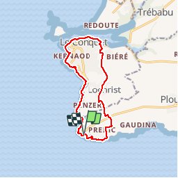
Trail Walking of 12.2 km to be discovered at Brittany, Finistère, Plougonvelin. This trail is proposed by mauricemear.

Description

Boucle de St Mathieu au Conquet sur le GR 34 et les chemins de campagne.

Elevation profile

Photos

Positioning

Country:
France
Region :
Brittany
Department/Province :
Finistère
Municipality :
Plougonvelin
Location:
Unknown
Start:(UTM)
368762 ; 5354557 (30U) N.

Comments

Please log in to post a review or rate the element


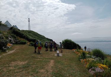
Super ballade ce 5 août 2020. Temps superbe comme d'habitude chez nous, pas trop de monde ! Nous sommes partis du Conquet, donc bord de la ria puis sentier côtier et retour par l'intérieur des terres. Merci Maurice R. DAGORN (Quimper Rando)


Trails nearby

Trail On foot Plougonvelin - Circuit de St Mathieu - Photo
On foot
PRO

On foot

Easy
Plougonvelin, Brittany, Finistère, France
4.3 km | 5 km-effort
1h 8min
No
Trail Walking Le Conquet - 10.09.23  Le Conquet  --  Plougonvelin - Photo
Walking
donda

Walking

Very difficult
Le Conquet, Brittany, Finistère, France
17.7 km | 21 km-effort
4h 48min
No
Trail Nordic walking Le Conquet - au sud du Conquet - Photo
Nordic walking
elianette

Nordic walking

Very easy
Le Conquet, Brittany, Finistère, France
42 km | 50 km-effort
22min
No
Trail Walking Le Conquet - presqu'île de Kermorvan - Photo
Walking
ahelvig

Walking

Easy
(2)
Le Conquet, Brittany, Finistère, France
10 km | 11.8 km-effort
2h 54min
Yes
Trail Walking Le Conquet - Pointe de Kermovan/Fort de l'Ilette. 22/08/19. - Photo
Walking
Dervalmarc

Walking

Easy
Le Conquet, Brittany, Finistère, France
3.9 km | 4.4 km-effort
1h 53min
Yes
Trail Walking Plougonvelin - Pointe St-Mathieu - Photo
Walking
tracegps

Walking

Very difficult
(1)
Plougonvelin, Brittany, Finistère, France
34 km | 43 km-effort
8h 30min
No
Trail Walking Le Conquet - Le Conquet - Pointe Saint-Mathieu - Photo
Walking
PascalXLD

Walking

Easy
Le Conquet, Brittany, Finistère, France
12.5 km | 14.6 km-effort
3h 44min
Yes
Trail Walking Le Conquet - Bordeaux d de côté conquet  - Photo
Walking
vincentdr

Walking

Easy
Le Conquet, Brittany, Finistère, France
3.8 km | 4.4 km-effort
54min
No
Trail Running Le Conquet - Le Conquet-19092019 - Photo
Running
kayamb

Running

Difficult
Le Conquet, Brittany, Finistère, France
19.7 km | 24 km-effort
3h 40min
Yes


Close
My subscriptions