


AURELLE RAVIB MAL INFERNET 10 KM

clintest
User
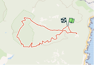

Length
10.2 km

Max alt
295 m

Uphill gradient
303 m
Km-Effort
14.2 km

Min alt
29 m

Downhill gradient
307 m
Boucle
Yes
Creation date :
2023-01-06 19:22:16.24
Updated on :
2023-01-06 19:24:12.256
3h14
Difficulty : Easy

FREE GPS app for hiking
 SityTrail
IGN / Geographical institutes
SityTrail Plus
The world is yours!
About
Trail On foot of 10.2 km to be discovered at Provence-Alpes-Côte d'Azur, Var, Saint-Raphaël. This trail is proposed by clintest.
Positioning
Country:
France
Region :
Provence-Alpes-Côte d'Azur
Department/Province :
Var
Municipality :
Saint-Raphaël
Location:
Unknown
Start:(Dec)
Start:(UTM)
330863 ; 4815105 (32T) N.
Comments