


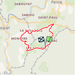
Forêt de la Grésigne

josy31
User

Length
13.7 km

Max alt
449 m

Uphill gradient
399 m
Km-Effort
19 km

Min alt
153 m

Downhill gradient
397 m
Boucle
Yes
Creation date :
2014-12-10 00:00:00.0
Updated on :
2014-12-10 00:00:00.0
4h04
Difficulty : Easy

FREE GPS app for hiking
 SityTrail
IGN / Geographical institutes
SityTrail Plus
The world is yours!
About
Trail Walking of 13.7 km to be discovered at Occitania, Tarn, Larroque. This trail is proposed by josy31.
Description
ballade agréable au coeur de la forêt
Positioning
Country:
France
Region :
Occitania
Department/Province :
Tarn
Municipality :
Larroque
Location:
Unknown
Start:(Dec)
Start:(UTM)
397182 ; 4877083 (31T) N.
Comments