


Col vert avec Véronique

pconte
User
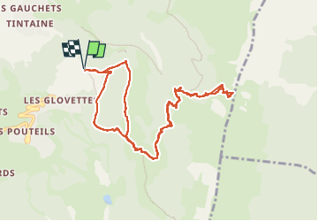

Length
11.4 km

Max alt
1746 m

Uphill gradient
579 m
Km-Effort
19.2 km

Min alt
1237 m

Downhill gradient
579 m
Boucle
Yes
Creation date :
2023-01-07 09:46:52.0
Updated on :
2023-01-07 15:52:19.125
4h36
Difficulty : Very difficult

FREE GPS app for hiking
 SityTrail
IGN / Geographical institutes
SityTrail Plus
The world is yours!
About
Trail Walking of 11.4 km to be discovered at Auvergne-Rhône-Alpes, Isère, Villard-de-Lans. This trail is proposed by pconte.
Positioning
Country:
France
Region :
Auvergne-Rhône-Alpes
Department/Province :
Isère
Municipality :
Villard-de-Lans
Location:
Unknown
Start:(Dec)
Start:(UTM)
702211 ; 4992386 (31T) N.
Comments