Trail Walking Gourbeyre - observation volcanique basse tere - Photo

observation volcanique basse tere

 rprotte
rprotte

User

© OpenStreetMap contributors
Length
Length
7 km
Max alt
Max alt
419 m
Uphill gradient
Uphill gradient
372 m
Km-Effort
Km-Effort  
11.9 km
Min alt
Min alt
32 m
Downhill gradient
Downhill gradient
376 m
Boucle
Boucle
Yes
Creation date :
2023-01-07 18:41:27.162
Updated on :
2023-01-07 21:08:27.533

(0 Reviews)

Walking
Walking
2h02
Difficulty : Medium

Scan this QR Code to open this trail in the SityTrail application

FREE GPS app for hiking

Logo SityTrail SityTrail

IGN / Geographical institutes

Download SityTrail from the App Store Download SityTrail from Google Play

Logo SityTrail SityTrail World

The world is yours!

Download SityTrail from the App Store Download SityTrail from Google Play Download SityTrail on Huawei AppGallery

About

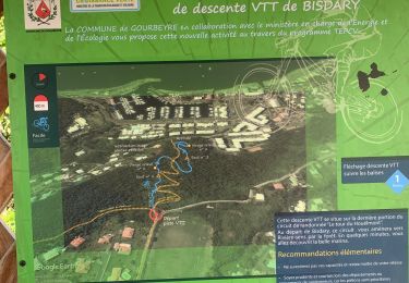
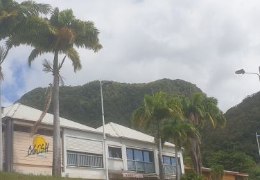
Trail Walking of 7 km to be discovered at Guadeloupe, Unknown, Gourbeyre. This trail is proposed by rprotte.

Description

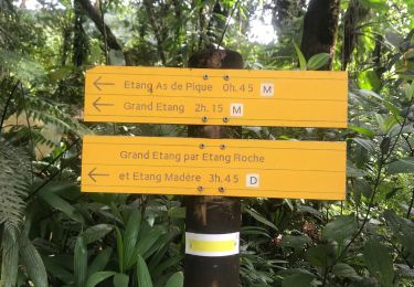
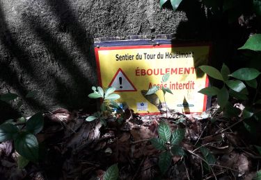
un norceau du chemin fermé pour éboulement. a mi chemin de la route nous pouvions reprendre mais maryse n'a  pas souhaité et à préféré rester sur route

Elevation profile

Positioning

Country:
France
Region :
Guadeloupe
Department/Province :
Unknown
Municipality :
Gourbeyre
Location:
Unknown
Start:(UTM)
637468 ; 1767627 (20P) N.

Trails nearby

Trail Nordic walking Gourbeyre - Centre volcanologique  - Photo
Nordic walking
sameja

Nordic walking

Medium
Gourbeyre, Guadeloupe, Unknown, France
6.5 km | 11.5 km-effort
1h 45min
Yes
Trail Trail Gourbeyre - Houėlmont observatoire volcanologique  - Photo
Trail
sameja

Trail

Difficult
Gourbeyre, Guadeloupe, Unknown, France
6.4 km | 11.5 km-effort
1h 22min
Yes
Trail Trail Gourbeyre - Gourbeyre - Photo
Trail
sameja

Trail

Difficult
Gourbeyre, Guadeloupe, Unknown, France
17.1 km | 27 km-effort
2h 10min
Yes
Trail Walking Saint-Claude - Soufrière - Photo
Walking
GUIDE
manuelPerez

Walking

Saint-Claude, Guadeloupe, Unknown, France
12.5 km | 21 km-effort
2h 46min
No
Trail Running Basse-Terre - Volcano Trail - Grand Raid de la Région Guadeloupe - Édition 2009 - Photo
Running
tracegps

Running

Very difficult
Basse-Terre, Guadeloupe, Unknown, France
44 km | 86 km-effort
11h 30min
No
Trail Walking Gourbeyre - reco exam poudriere - Photo
Walking
ThereseH

Walking

Medium
Gourbeyre, Guadeloupe, Unknown, France
5.5 km | 9.4 km-effort
2h 37min
Yes
Trail Walking Gourbeyre - Boucle du Morne Cadet - Photo
Walking
RANDOTOURVES02

Walking

Difficult
Gourbeyre, Guadeloupe, Unknown, France
9.8 km | 18.7 km-effort
5h 46min
Yes
Trail Walking Vieux-Fort - cascade plessis - Photo
Walking
fanhan

Walking

Very easy
Vieux-Fort, Guadeloupe, Unknown, France
11.2 km | 21 km-effort
46min
No
Trail Trail Gourbeyre - Bisdary  - Photo
Trail
sameja

Trail

Very difficult
Gourbeyre, Guadeloupe, Unknown, France
6.5 km | 12.3 km-effort
1h 13min
Yes


Close
My subscriptions