


Châtillon sur cher

lecmic
User
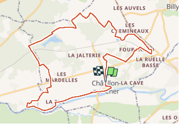

Length
25 km

Max alt
116 m

Uphill gradient
222 m
Km-Effort
28 km

Min alt
70 m

Downhill gradient
220 m
Boucle
Yes
Creation date :
2023-01-08 06:16:29.756
Updated on :
2023-01-08 10:49:12.738
4h32
Difficulty : Medium

FREE GPS app for hiking
 SityTrail
IGN / Geographical institutes
SityTrail Plus
The world is yours!
About
Trail Walking of 25 km to be discovered at Centre-Loire Valley, Loir-et-Cher, Châtillon-sur-Cher. This trail is proposed by lecmic.
Description
rando
Positioning
Country:
France
Region :
Centre-Loire Valley
Department/Province :
Loir-et-Cher
Municipality :
Châtillon-sur-Cher
Location:
Unknown
Start:(Dec)
Start:(UTM)
386099 ; 5236927 (31T) N.
Comments