


St rose

sameja
User
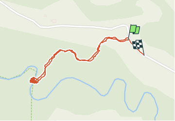

Length
1.9 km

Max alt
150 m

Uphill gradient
32 m
Km-Effort
2.4 km

Min alt
126 m

Downhill gradient
42 m
Boucle
Yes
Creation date :
2023-01-08 10:51:43.0
Updated on :
2023-01-08 12:55:10.423
41m
Difficulty : Easy

FREE GPS app for hiking
 SityTrail
IGN / Geographical institutes
SityTrail Plus
The world is yours!
About
Trail Walking of 1.9 km to be discovered at Guadeloupe, Unknown, Sainte-Rose. This trail is proposed by sameja.
Description
Rivière bras
Positioning
Country:
France
Region :
Guadeloupe
Department/Province :
Unknown
Municipality :
Sainte-Rose
Location:
Unknown
Start:(Dec)
Start:(UTM)
638711 ; 1799509 (20Q) N.
Comments