


Ota Marignana

Clo0413
User
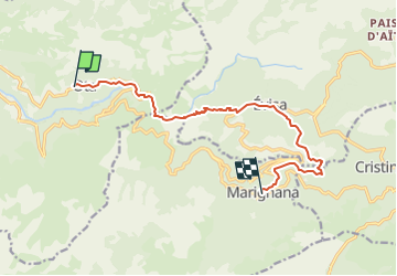

Length
11.9 km

Max alt
829 m

Uphill gradient
792 m
Km-Effort
21 km

Min alt
206 m

Downhill gradient
409 m
Boucle
No
Creation date :
2023-01-08 15:58:01.211
Updated on :
2023-01-08 16:40:31.779
4h49
Difficulty : Very difficult

FREE GPS app for hiking
 SityTrail
IGN / Geographical institutes
SityTrail Plus
The world is yours!
About
Trail Walking of 11.9 km to be discovered at Corsica, South Corsica, Ota. This trail is proposed by Clo0413.
Positioning
Country:
France
Region :
Corsica
Department/Province :
South Corsica
Municipality :
Ota
Location:
Unknown
Start:(Dec)
Start:(UTM)
478720 ; 4678388 (32T) N.
Comments