


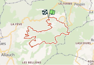
Vallon de l'Amandier - 7270 - UtagawaVTT.com

Alain Derrives
User

Length
22 km

Max alt
689 m

Uphill gradient
717 m
Km-Effort
31 km

Min alt
280 m

Downhill gradient
713 m
Boucle
Yes
Creation date :
2023-01-09 12:16:11.67
Updated on :
2023-01-09 12:16:56.583
2h11
Difficulty : Difficult

FREE GPS app for hiking
 SityTrail
IGN / Geographical institutes
SityTrail Plus
The world is yours!
About
Trail Mountain bike of 22 km to be discovered at Provence-Alpes-Côte d'Azur, Bouches-du-Rhône, Allauch. This trail is proposed by Alain Derrives.
Positioning
Country:
France
Region :
Provence-Alpes-Côte d'Azur
Department/Province :
Bouches-du-Rhône
Municipality :
Allauch
Location:
Unknown
Start:(Dec)
Start:(UTM)
705546 ; 4805084 (31T) N.
Comments