


Croix de Chamrousse

oliviergau
User
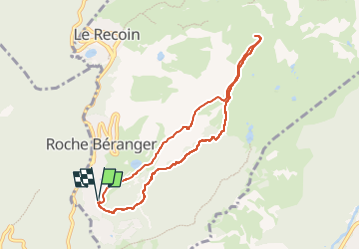

Length
7.8 km

Max alt
2250 m

Uphill gradient
516 m
Km-Effort
14.7 km

Min alt
1730 m

Downhill gradient
514 m
Boucle
Yes
Creation date :
2023-01-10 08:08:17.198
Updated on :
2023-01-10 10:35:42.625
2h27
Difficulty : Very easy

FREE GPS app for hiking
 SityTrail
IGN / Geographical institutes
SityTrail Plus
The world is yours!
About
Trail Touring skiing of 7.8 km to be discovered at Auvergne-Rhône-Alpes, Isère, Chamrousse. This trail is proposed by oliviergau.
Positioning
Country:
France
Region :
Auvergne-Rhône-Alpes
Department/Province :
Isère
Municipality :
Chamrousse
Location:
Unknown
Start:(Dec)
Start:(UTM)
726227 ; 4998750 (31T) N.
Comments