


essai

Liebeaux
User

Length
177 m

Max alt
479 m

Uphill gradient
23 m
Km-Effort
407 m

Min alt
443 m

Downhill gradient
0 m
Boucle
No
Creation date :
2023-01-12 09:06:31.567
Updated on :
2023-01-12 09:12:12.092
5m
Difficulty : Easy

FREE GPS app for hiking
 SityTrail
IGN / Geographical institutes
SityTrail Plus
The world is yours!
About
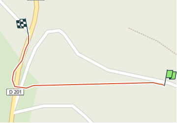
Trail Walking of 177 m to be discovered at Auvergne-Rhône-Alpes, Isère, Cras. This trail is proposed by Liebeaux.
Positioning
Country:
France
Region :
Auvergne-Rhône-Alpes
Department/Province :
Isère
Municipality :
Cras
Location:
Unknown
Start:(Dec)
Start:(UTM)
691334 ; 5015523 (31T) N.
Comments