


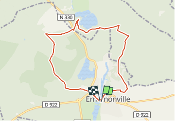
SM_ERMENONVILLE CHATEAU_NORD_8.1Km

GR77LP
User

Length
8.1 km

Max alt
123 m

Uphill gradient
109 m
Km-Effort
9.5 km

Min alt
69 m

Downhill gradient
111 m
Boucle
Yes
Creation date :
2023-01-12 15:04:41.271
Updated on :
2023-01-12 15:41:40.472
2h12
Difficulty : Easy

FREE GPS app for hiking
 SityTrail
IGN / Geographical institutes
SityTrail Plus
The world is yours!
About
Trail Walking of 8.1 km to be discovered at Hauts-de-France, Oise, Ermenonville. This trail is proposed by GR77LP.
Description
https://www.goelerando.fr/
DAMMARTIN en GOELE 77
Parking-Départ-Arrivée : Place du Marché, face au chateau d'Ermenonville
Photos

Positioning
Country:
France
Region :
Hauts-de-France
Department/Province :
Oise
Municipality :
Ermenonville
Location:
Unknown
Start:(Dec)
Start:(UTM)
477629 ; 5441436 (31U) N.
Comments