


La Lance

andrechauvin
User
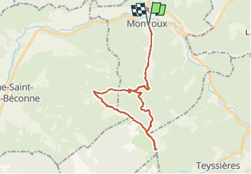

Length
17.1 km

Max alt
1327 m

Uphill gradient
865 m
Km-Effort
29 km

Min alt
476 m

Downhill gradient
862 m
Boucle
Yes
Creation date :
2023-01-12 08:08:08.143
Updated on :
2023-01-12 16:33:50.041
6h22
Difficulty : Difficult

FREE GPS app for hiking
 SityTrail
IGN / Geographical institutes
SityTrail Plus
The world is yours!
About
Trail Walking of 17.1 km to be discovered at Auvergne-Rhône-Alpes, Drôme, Montjoux. This trail is proposed by andrechauvin.
Description
rando sympa
Positioning
Country:
France
Region :
Auvergne-Rhône-Alpes
Department/Province :
Drôme
Municipality :
Montjoux
Location:
Unknown
Start:(Dec)
Start:(UTM)
666785 ; 4929517 (31T) N.
Comments