


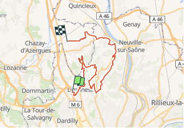
Limonest 2-montagnards-hangar ouverture itinéraire

ophness
User

Length
29 km

Max alt
592 m

Uphill gradient
904 m
Km-Effort
42 km

Min alt
184 m

Downhill gradient
1035 m
Boucle
No
Creation date :
2023-01-12 19:44:29.584
Updated on :
2023-01-12 19:45:05.086
5h29
Difficulty : Very difficult

FREE GPS app for hiking
 SityTrail
IGN / Geographical institutes
SityTrail Plus
The world is yours!
About
Trail Horseback riding of 29 km to be discovered at Auvergne-Rhône-Alpes, Métropole de Lyon, Limonest. This trail is proposed by ophness.
Positioning
Country:
France
Region :
Auvergne-Rhône-Alpes
Department/Province :
Métropole de Lyon
Municipality :
Limonest
Location:
Unknown
Start:(Dec)
Start:(UTM)
636707 ; 5076971 (31T) N.
Comments