


Tauriers trois clochers

pb07
User
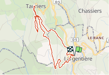

Length
5.9 km

Max alt
459 m

Uphill gradient
268 m
Km-Effort
9.5 km

Min alt
222 m

Downhill gradient
268 m
Boucle
Yes
Creation date :
2023-01-13 13:29:28.659
Updated on :
2023-01-13 17:08:46.646
2h27
Difficulty : Very difficult

FREE GPS app for hiking
 SityTrail
IGN / Geographical institutes
SityTrail Plus
The world is yours!
About
Trail Walking of 5.9 km to be discovered at Auvergne-Rhône-Alpes, Ardèche, Largentière. This trail is proposed by pb07.
Positioning
Country:
France
Region :
Auvergne-Rhône-Alpes
Department/Province :
Ardèche
Municipality :
Largentière
Location:
Unknown
Start:(Dec)
Start:(UTM)
602657 ; 4932924 (31T) N.
Comments