Trail Walking Sigy-le-Châtel - Sigy Le Chatel - Photo
© OpenStreetMap contributors
Length
Length
10.7 km
Max alt
Max alt
409 m
Uphill gradient
Uphill gradient
248 m
Km-Effort
Km-Effort  
14 km
Min alt
Min alt
217 m
Downhill gradient
Downhill gradient
260 m
Boucle
Boucle
Yes
Creation date :
2023-01-13 20:21:56.255
Updated on :
2023-03-07 17:37:45.528

(1 Reviews)

Walking
Walking
3h11
Difficulty : Easy

Scan this QR Code to open this trail in the SityTrail application

FREE GPS app for hiking

Logo SityTrail SityTrail

IGN / Geographical institutes

Download SityTrail from the App Store Download SityTrail from Google Play

Logo SityTrail SityTrail World

The world is yours!

Download SityTrail from the App Store Download SityTrail from Google Play Download SityTrail on Huawei AppGallery

About

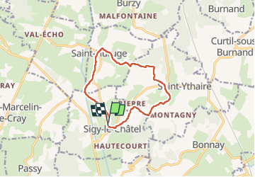
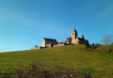
Trail Walking of 10.7 km to be discovered at Bourgogne-Franche-Comté, Saône-et-Loire, Sigy-le-Châtel. This trail is proposed by Bonnefois Bernard.

Description

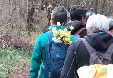
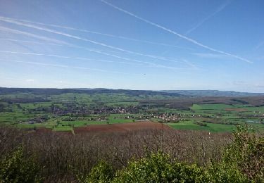
Randonnée de 1km permettant de visiter les villages et châteaux de Sigy le Chatel et Saint-Huruge avec dr jolies vues sur la vallée de la Guye et depuis le belvédère de Chassignol

Elevation profile

Positioning

Country:
France
Region :
Bourgogne-Franche-Comté
Department/Province :
Saône-et-Loire
Municipality :
Sigy-le-Châtel
Location:
Unknown
Start:(UTM)
620550 ; 5157022 (31T) N.

Comments

Please log in to post a review or rate the element


très belle randonnée,mais pas du tout difficile comme indiqué


Trails nearby

Trail Walking Saint-Ythaire - Saint Ythaire  Les Jonquilles page 104 - Photo
Walking
grasgilbert

Walking

Medium
(5)
Saint-Ythaire, Bourgogne-Franche-Comté, Saône-et-Loire, France
12.3 km | 17.2 km-effort
3h 36min
Yes
Trail Walking Saint-Ythaire - 2023-03-04_12h49m01_SityTrail - 2356343 - saint-ythaire--les-jonquilles-page-104 - Photo
Walking
jcbossant

Walking

Difficult
(1)
Saint-Ythaire, Bourgogne-Franche-Comté, Saône-et-Loire, France
12.3 km | 17.2 km-effort
3h 54min
Yes
Trail Mountain bike Bonnay - Besanceuil  - Photo
Mountain bike
darrisa

Mountain bike

Medium
(1)
Bonnay, Bourgogne-Franche-Comté, Saône-et-Loire, France
11.2 km | 15.7 km-effort
3h 52min
Yes
Trail Walking Saint-Huruge - Mamou cross the hill - Photo
Walking
margotjl

Walking

Easy
Saint-Huruge, Bourgogne-Franche-Comté, Saône-et-Loire, France
6.1 km | 7.5 km-effort
1h 52min
Yes
Trail Walking Saint-Ythaire - oh! les beaux village - Photo
Walking
margotjl

Walking

Medium
Saint-Ythaire, Bourgogne-Franche-Comté, Saône-et-Loire, France
8.4 km | 11.7 km-effort
2h 28min
Yes
Trail Walking Salornay-sur-Guye - 20190822 Salornay sur Guye G3 GC - Photo
Walking
sami55

Walking

Easy
(1)
Salornay-sur-Guye, Bourgogne-Franche-Comté, Saône-et-Loire, France
10.2 km | 14.2 km-effort
3h 2min
Yes
Trail Walking Saint-Ythaire - ythair - Photo
Walking
charlolga

Walking

Medium
Saint-Ythaire, Bourgogne-Franche-Comté, Saône-et-Loire, France
13.8 km | 19.5 km-effort
3h 21min
Yes
Trail Walking Sigy-le-Châtel - si gt jonquilles  - Photo
Walking
clozelmarie

Walking

Medium
(2)
Sigy-le-Châtel, Bourgogne-Franche-Comté, Saône-et-Loire, France
8.4 km | 12 km-effort
3h 15min
Yes
Trail Walking Salornay-sur-Guye - circuit salornay sentier du bois de la roche - Photo
Walking
jbsky71

Walking

Easy
Salornay-sur-Guye, Bourgogne-Franche-Comté, Saône-et-Loire, France
8.6 km | 11.8 km-effort
2h 8min
Yes


Close
My subscriptions