


depart saumane de vaucluse ; vers fontaine de vaucluse

gerardmicheline
User
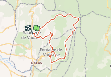

Length
19.6 km

Max alt
662 m

Uphill gradient
828 m
Km-Effort
31 km

Min alt
79 m

Downhill gradient
827 m
Boucle
Yes
Creation date :
2023-01-14 16:31:32.725
Updated on :
2023-01-14 16:32:26.649
6h57
Difficulty : Very difficult

FREE GPS app for hiking
 SityTrail
IGN / Geographical institutes
SityTrail Plus
The world is yours!
About
Trail Walking of 19.6 km to be discovered at Provence-Alpes-Côte d'Azur, Vaucluse, Saumane-de-Vaucluse. This trail is proposed by gerardmicheline.
Positioning
Country:
France
Region :
Provence-Alpes-Côte d'Azur
Department/Province :
Vaucluse
Municipality :
Saumane-de-Vaucluse
Location:
Unknown
Start:(Dec)
Start:(UTM)
669024 ; 4866910 (31T) N.
Comments