


escaliers xrousse

edwige84
User
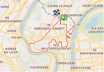

Length
9.2 km

Max alt
258 m

Uphill gradient
327 m
Km-Effort
13.5 km

Min alt
165 m

Downhill gradient
329 m
Boucle
No
Creation date :
2023-01-15 12:52:01.571
Updated on :
2024-07-05 18:51:35.511
3h04
Difficulty : Difficult

FREE GPS app for hiking
 SityTrail
IGN / Geographical institutes
SityTrail Plus
The world is yours!
About
Trail Walking of 9.2 km to be discovered at Auvergne-Rhône-Alpes, Métropole de Lyon, Lyon. This trail is proposed by edwige84.
Positioning
Country:
France
Region :
Auvergne-Rhône-Alpes
Department/Province :
Métropole de Lyon
Municipality :
Lyon
Location:
Lyon 4e Arrondissement
Start:(Dec)
Start:(UTM)
642445 ; 5071191 (31T) N.
Comments