


Tanneron-les mimosas-13-01-23

Christiancordin
User

Length
16.1 km

Max alt
480 m

Uphill gradient
532 m
Km-Effort
23 km

Min alt
155 m

Downhill gradient
532 m
Boucle
Yes
Creation date :
2023-01-15 17:38:15.027
Updated on :
2023-01-15 17:47:17.594
5h16
Difficulty : Medium

FREE GPS app for hiking
 SityTrail
IGN / Geographical institutes
SityTrail Plus
The world is yours!
About
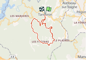
Trail On foot of 16.1 km to be discovered at Provence-Alpes-Côte d'Azur, Var, Tanneron. This trail is proposed by Christiancordin.
Description
Tanneron Pk après la mairie à droite conseillé aux randonneurs-colle d'Embarque-vallon des Serres-vallon de l'Aubarie-les Farinas-les Grailles-Les Margoutons-vallon de Latone-Tanneron.
Photos


Positioning
Country:
France
Region :
Provence-Alpes-Côte d'Azur
Department/Province :
Var
Municipality :
Tanneron
Location:
Unknown
Start:(Dec)
Start:(UTM)
328553 ; 4828538 (32T) N.
Comments