


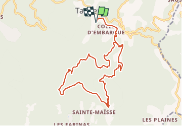
Tanneron 1 - Circuit mimosa

soca
User

Length
12.1 km

Max alt
408 m

Uphill gradient
537 m
Km-Effort
19.3 km

Min alt
200 m

Downhill gradient
537 m
Boucle
Yes
Creation date :
2023-01-16 05:15:08.487
Updated on :
2023-01-16 05:42:37.166
5h00
Difficulty : Difficult

FREE GPS app for hiking
 SityTrail
IGN / Geographical institutes
SityTrail Plus
The world is yours!
About
Trail Walking of 12.1 km to be discovered at Provence-Alpes-Côte d'Azur, Var, Tanneron. This trail is proposed by soca.
Description
Tanneron - Carreirou - la verrerie - vers la colle du mouton - vallon des Peyrines - Cague Denier - retour vers Carreirou- Tanneron
Positioning
Country:
France
Region :
Provence-Alpes-Côte d'Azur
Department/Province :
Var
Municipality :
Tanneron
Location:
Unknown
Start:(Dec)
Start:(UTM)
328614 ; 4828224 (32T) N.
Comments