


Tafraoute

carole5983
User
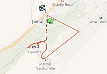

Length
2.4 km

Max alt
1027 m

Uphill gradient
41 m
Km-Effort
3 km

Min alt
997 m

Downhill gradient
43 m
Boucle
Yes
Creation date :
2023-01-17 09:39:57.122
Updated on :
2023-01-17 11:25:18.126
1h37
Difficulty : Very easy

FREE GPS app for hiking
 SityTrail
IGN / Geographical institutes
SityTrail Plus
The world is yours!
About
Trail Walking of 2.4 km to be discovered at Souss-Massa, Pachalik de Tafraout, Tafraout. This trail is proposed by carole5983.
Description
Visite d'un maison berbère
Positioning
Country:
Morocco
Region :
Souss-Massa
Department/Province :
Pachalik de Tafraout
Municipality :
Tafraout
Location:
Unknown
Start:(Dec)
Start:(UTM)
501282 ; 3287086 (29R) N.
Comments