


activity_1510070293

loic09
User
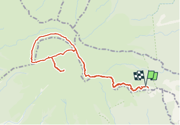

Length
10.3 km

Max alt
1380 m

Uphill gradient
947 m
Km-Effort
23 km

Min alt
813 m

Downhill gradient
956 m
Boucle
Yes
Creation date :
2023-01-17 15:58:53.238
Updated on :
2023-01-20 14:00:23.756
0m
Difficulty : Difficult

FREE GPS app for hiking
 SityTrail
IGN / Geographical institutes
SityTrail Plus
The world is yours!
About
Trail Trail of 10.3 km to be discovered at Martinique, Unknown, L'Ajoupa-Bouillon. This trail is proposed by loic09.
Description
Quelques allés et retour en mode Trail
Positioning
Country:
France
Region :
Martinique
Department/Province :
Unknown
Municipality :
L'Ajoupa-Bouillon
Location:
Unknown
Start:(Dec)
Start:(UTM)
698951 ; 1637729 (20P) N.
Comments