


activity_1510068869

loic09
User
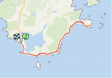

Length
15.6 km

Max alt
29 m

Uphill gradient
148 m
Km-Effort
17.5 km

Min alt
0 m

Downhill gradient
148 m
Boucle
Yes
Creation date :
2023-01-17 16:24:40.95
Updated on :
2023-01-17 16:28:13.404
--
Difficulty : Unknown

FREE GPS app for hiking
 SityTrail
IGN / Geographical institutes
SityTrail Plus
The world is yours!
About
Trail Running of 15.6 km to be discovered at Martinique, Unknown, Sainte-Anne. This trail is proposed by loic09.
Description
Aller retour Anse des Salines/Savane des petrifications
Positioning
Country:
France
Region :
Martinique
Department/Province :
Unknown
Municipality :
Sainte-Anne
Location:
Unknown
Start:(Dec)
Start:(UTM)
728890 ; 1593287 (20P) N.
Comments