


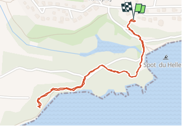
Tipayoune - Bois Jolan

AMOROS
User

Length
1.9 km

Max alt
14 m

Uphill gradient
25 m
Km-Effort
2.3 km

Min alt
0 m

Downhill gradient
26 m
Boucle
Yes
Creation date :
2023-01-17 19:13:22.0
Updated on :
2023-01-17 21:01:54.948
47m
Difficulty : Easy

FREE GPS app for hiking
 SityTrail
IGN / Geographical institutes
SityTrail Plus
The world is yours!
About
Trail Walking of 1.9 km to be discovered at Guadeloupe, Unknown, Sainte-Anne. This trail is proposed by AMOROS.
Positioning
Country:
France
Region :
Guadeloupe
Department/Province :
Unknown
Municipality :
Sainte-Anne
Location:
Unknown
Start:(Dec)
Start:(UTM)
677421 ; 1796517 (20Q) N.
Comments