


y10_eison_nax

My Switzerland
Optez pour le retour à la nature GUIDE+
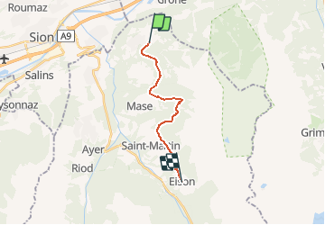

Length
13 km

Max alt
1808 m

Uphill gradient
740 m
Km-Effort
22 km

Min alt
1374 m

Downhill gradient
473 m
Boucle
No
Creation date :
2014-12-10 00:00:00.0
Updated on :
2014-12-10 00:00:00.0
5h21
Difficulty : Unknown

FREE GPS app for hiking
 SityTrail
IGN / Geographical institutes
SityTrail Plus
The world is yours!
About
Trail Other activity of 13 km to be discovered at Valais/Wallis, Hérens, Mont-Noble. This trail is proposed by My Switzerland.


Positioning
Country:
Switzerland
Region :
Valais/Wallis
Department/Province :
Hérens
Municipality :
Mont-Noble
Location:
Unknown
Start:(Dec)
Start:(UTM)
379809 ; 5120575 (32T) N.
Comments