


bois brûlé geyssans

brigitBB26
User
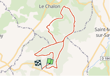

Length
10.3 km

Max alt
483 m

Uphill gradient
182 m
Km-Effort
12.8 km

Min alt
384 m

Downhill gradient
195 m
Boucle
Yes
Creation date :
2022-12-18 08:19:58.026
Updated on :
2023-01-18 13:49:25.199
3h15
Difficulty : Easy

FREE GPS app for hiking
 SityTrail
IGN / Geographical institutes
SityTrail Plus
The world is yours!
About
Trail Walking of 10.3 km to be discovered at Auvergne-Rhône-Alpes, Drôme, Geyssans. This trail is proposed by brigitBB26.
Positioning
Country:
France
Region :
Auvergne-Rhône-Alpes
Department/Province :
Drôme
Municipality :
Geyssans
Location:
Unknown
Start:(Dec)
Start:(UTM)
664072 ; 4999507 (31T) N.
Comments