


activity_10055340498

loic09
User
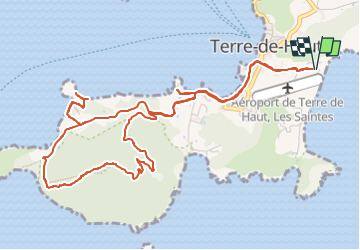

Length
9.5 km

Max alt
295 m

Uphill gradient
415 m
Km-Effort
15 km

Min alt
1 m

Downhill gradient
415 m
Boucle
Yes
Creation date :
2023-01-18 14:54:48.415
Updated on :
2023-01-18 14:58:53.941
--
Difficulty : Unknown

FREE GPS app for hiking
 SityTrail
IGN / Geographical institutes
SityTrail Plus
The world is yours!
About
Trail Trail of 9.5 km to be discovered at Guadeloupe, Unknown, Terre-de-Haut. This trail is proposed by loic09.
Positioning
Country:
France
Region :
Guadeloupe
Department/Province :
Unknown
Municipality :
Terre-de-Haut
Location:
Unknown
Start:(Dec)
Start:(UTM)
652269 ; 1754639 (20P) N.
Comments