


rando raquette

xst
User
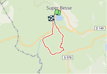

Length
4.7 km

Max alt
1303 m

Uphill gradient
115 m
Km-Effort
6.2 km

Min alt
1207 m

Downhill gradient
121 m
Boucle
No
Creation date :
2023-01-18 12:44:23.777
Updated on :
2023-01-18 15:12:55.917
1h49
Difficulty : Medium

FREE GPS app for hiking
 SityTrail
IGN / Geographical institutes
SityTrail Plus
The world is yours!
About
Trail Snowshoes of 4.7 km to be discovered at Auvergne-Rhône-Alpes, Puy-de-Dôme, Besse-et-Saint-Anastaise. This trail is proposed by xst.
Description
circuit balisé numéro 2.
Très belle neige.
Positioning
Country:
France
Region :
Auvergne-Rhône-Alpes
Department/Province :
Puy-de-Dôme
Municipality :
Besse-et-Saint-Anastaise
Location:
Unknown
Start:(Dec)
Start:(UTM)
488519 ; 5039265 (31T) N.
Comments