


depart crestet; crete de l'arfuyen et crete saint armand

gerardmicheline
User
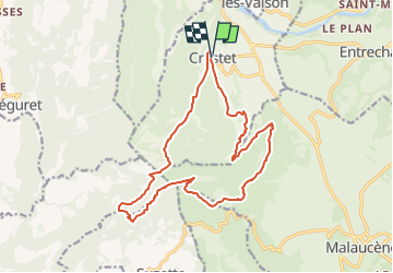

Length
17.5 km

Max alt
725 m

Uphill gradient
646 m
Km-Effort
26 km

Min alt
284 m

Downhill gradient
646 m
Boucle
Yes
Creation date :
2023-01-18 17:09:27.092
Updated on :
2023-01-18 17:10:40.8
5h56
Difficulty : Medium

FREE GPS app for hiking
 SityTrail
IGN / Geographical institutes
SityTrail Plus
The world is yours!
About
Trail On foot of 17.5 km to be discovered at Provence-Alpes-Côte d'Azur, Vaucluse, Crestet. This trail is proposed by gerardmicheline.
Positioning
Country:
France
Region :
Provence-Alpes-Côte d'Azur
Department/Province :
Vaucluse
Municipality :
Crestet
Location:
Unknown
Start:(Dec)
Start:(UTM)
666539 ; 4897996 (31T) N.
Comments