


saillans chabrier

collot
User
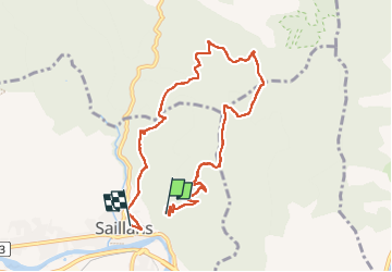

Length
8.9 km

Max alt
785 m

Uphill gradient
374 m
Km-Effort
14.4 km

Min alt
275 m

Downhill gradient
531 m
Boucle
No
Creation date :
2022-12-01 09:44:07.438
Updated on :
2023-01-18 17:24:33.674
4h55
Difficulty : Difficult

FREE GPS app for hiking
 SityTrail
IGN / Geographical institutes
SityTrail Plus
The world is yours!
About
Trail Walking of 8.9 km to be discovered at Auvergne-Rhône-Alpes, Drôme, Saillans. This trail is proposed by collot.
Positioning
Country:
France
Region :
Auvergne-Rhône-Alpes
Department/Province :
Drôme
Municipality :
Saillans
Location:
Unknown
Start:(Dec)
Start:(UTM)
674611 ; 4951892 (31T) N.
Comments