Trail Walking Saint-Jeannet - Baou de Saint-Jeannet - Photo
© OpenStreetMap contributors
Length
Length
7.5 km
Max alt
Max alt
810 m
Uphill gradient
Uphill gradient
433 m
Km-Effort
Km-Effort  
13.4 km
Min alt
Min alt
372 m
Downhill gradient
Downhill gradient
495 m
Boucle
Boucle
No
Creation date :
2023-01-19 08:53:06.594
Updated on :
2023-02-05 18:32:26.412

(1 Reviews)

Walking
Walking
3h15
Difficulty : Medium

Scan this QR Code to open this trail in the SityTrail application

FREE GPS app for hiking

Logo SityTrail SityTrail

IGN / Geographical institutes

Download SityTrail from the App Store Download SityTrail from Google Play

Logo SityTrail SityTrail World

The world is yours!

Download SityTrail from the App Store Download SityTrail from Google Play Download SityTrail on Huawei AppGallery

About

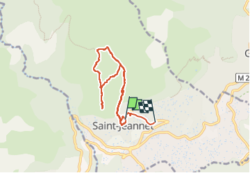
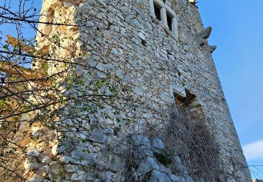
Trail Walking of 7.5 km to be discovered at Provence-Alpes-Côte d'Azur, Maritime Alps, Saint-Jeannet. This trail is proposed by Jean-François Thibaud.

Description

Randonnée classique de la région Niçoise. Se garer dans un des parking sur la gauche avant d'entrer dans le village.  Marcher dans la rue principale puis le départ sera indiqué.

Elevation profile

Photos

Positioning

Country:
France
Region :
Provence-Alpes-Côte d'Azur
Department/Province :
Maritime Alps
Municipality :
Saint-Jeannet
Location:
Unknown
Start:(UTM)
350526 ; 4845644 (32T) N.

Comments

Please log in to post a review or rate the element


Merci pour vos partages de randonnées


Trails nearby

Trail On foot Vence - Circuit des Blaquières - Photo
On foot
PRO

On foot

Easy
Vence, Provence-Alpes-Côte d'Azur, Maritime Alps, France
5.2 km | 8.6 km-effort
1h 57min
Yes
Trail On foot Gattières - Baou de la Gaude - Photo
On foot
PRO

On foot

Easy
Gattières, Provence-Alpes-Côte d'Azur, Maritime Alps, France
9.5 km | 17.7 km-effort
4h 1min
Yes
Trail On foot Carros - Les Balcons de Carros - Photo
On foot
PRO

On foot

Easy
Carros, Provence-Alpes-Côte d'Azur, Maritime Alps, France
4.9 km | 9.1 km-effort
2h 4min
Yes
Trail On foot Vence - Plan des Noves - Photo
On foot
PRO

On foot

Easy
Vence, Provence-Alpes-Côte d'Azur, Maritime Alps, France
7.2 km | 10.3 km-effort
2h 20min
Yes
Trail On foot Saint-Jeannet - Circuit du Castellet - Photo
On foot
PRO

On foot

Easy
Saint-Jeannet, Provence-Alpes-Côte d'Azur, Maritime Alps, France
8.2 km | 14.1 km-effort
3h 12min
Yes
Trail Walking Vence - Vence le Baou des Blancs - Photo
Walking
ch2slv

Walking

Easy
(2)
Vence, Provence-Alpes-Côte d'Azur, Maritime Alps, France
7.3 km | 11.2 km-effort
2h 24min
Yes
Trail Walking Saint-Jeannet - Baous de la Gaude et de St Jeannet - Photo
Walking
GrouGary

Walking

Medium
Saint-Jeannet, Provence-Alpes-Côte d'Azur, Maritime Alps, France
15 km | 26 km-effort
5h 51min
Yes
Trail Walking La Gaude - La Gaude - Bord de Cagnes - Photo
Walking
triburemy

Walking

Very difficult
La Gaude, Provence-Alpes-Côte d'Azur, Maritime Alps, France
7.7 km | 11.4 km-effort
3h 19min
Yes
Trail Walking Saint-Jeannet - st jeannet - Photo
Walking
triburemy

Walking

Difficult
Saint-Jeannet, Provence-Alpes-Côte d'Azur, Maritime Alps, France
4.6 km | 7.7 km-effort
1h 59min
No


Close
My subscriptions