Trail Walking Almuñécar - Rescate au dessus - Photo

Rescate au dessus

© OpenStreetMap contributors
Length
Length
5.1 km
Max alt
Max alt
720 m
Uphill gradient
Uphill gradient
262 m
Km-Effort
Km-Effort  
8.6 km
Min alt
Min alt
476 m
Downhill gradient
Downhill gradient
260 m
Boucle
Boucle
Yes
Creation date :
2023-01-19 11:59:51.068
Updated on :
2023-01-22 09:05:26.482

(0 Reviews)

Walking
Walking
2h10
Difficulty : Medium

Scan this QR Code to open this trail in the SityTrail application

FREE GPS app for hiking

Logo SityTrail SityTrail

IGN / Geographical institutes

Download SityTrail from the App Store Download SityTrail from Google Play

Logo SityTrail SityTrail Plus

The world is yours!

Download SityTrail from the App Store Download SityTrail from Google Play Download SityTrail on Huawei AppGallery

About

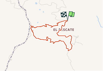
Trail Walking of 5.1 km to be discovered at Andalusia, Granada, Almuñécar. This trail is proposed by jpipacific.

Description

La première partie en montée n'est pas facile dans un chemin quasiment disparu. Ca grimpe dur au milieu des broussailles sans pause. Pas très agréable.
Le départ du retour est a chercher dans la plantation d'olivier puis le chemin devient très facile à suivre, en descente jusqu'à l'arrivée.
Points de vue magnifiques sur les montagnes environnantes, la Sierra Nevada enneigée au loin et la vue sur la mer de Motril à Velez Malaga

Elevation profile

Photos

Positioning

Country:
Spain
Region :
Andalusia
Department/Province :
Granada
Municipality :
Almuñécar
Location:
Unknown
Start:(UTM)
432676 ; 4071786 (30S) N.


Close
My subscriptions