


les ragages de Belgentier

bernir
User

Length
14.3 km

Max alt
623 m

Uphill gradient
564 m
Km-Effort
22 km

Min alt
153 m

Downhill gradient
565 m
Boucle
Yes
Creation date :
2023-01-20 08:36:04.233
Updated on :
2023-01-22 08:37:31.286
7h47
Difficulty : Medium

FREE GPS app for hiking
 SityTrail
IGN / Geographical institutes
SityTrail Plus
The world is yours!
About
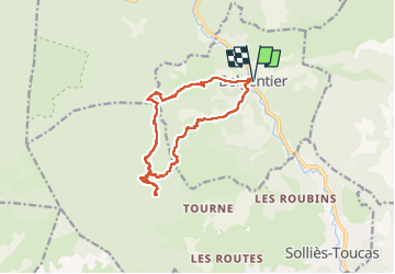
Trail Walking of 14.3 km to be discovered at Provence-Alpes-Côte d'Azur, Var, Belgentier. This trail is proposed by bernir.
Positioning
Country:
France
Region :
Provence-Alpes-Côte d'Azur
Department/Province :
Var
Municipality :
Belgentier
Location:
Unknown
Start:(Dec)
Start:(UTM)
256476 ; 4792395 (32T) N.
Comments