


st aubin dourlers floursies dourlers st aubin

brunobuj
User
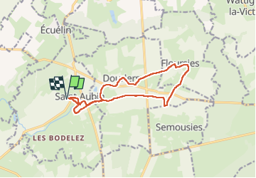

Length
12.1 km

Max alt
194 m

Uphill gradient
99 m
Km-Effort
13.4 km

Min alt
154 m

Downhill gradient
99 m
Boucle
Yes
Creation date :
2023-01-21 12:48:40.86
Updated on :
2023-01-21 15:12:31.206
2h23
Difficulty : Difficult

FREE GPS app for hiking
 SityTrail
IGN / Geographical institutes
SityTrail Plus
The world is yours!
About
Trail Walking of 12.1 km to be discovered at Hauts-de-France, Nord, Saint-Aubin. This trail is proposed by brunobuj.
Positioning
Country:
France
Region :
Hauts-de-France
Department/Province :
Nord
Municipality :
Saint-Aubin
Location:
Unknown
Start:(Dec)
Start:(UTM)
565314 ; 5558210 (31U) N.
Comments