


Margny

pascha
User
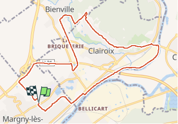

Length
11.6 km

Max alt
91 m

Uphill gradient
148 m
Km-Effort
13.6 km

Min alt
24 m

Downhill gradient
146 m
Boucle
Yes
Creation date :
2023-01-22 07:58:06.0
Updated on :
2023-01-22 11:04:42.794
3h05
Difficulty : Easy

FREE GPS app for hiking
 SityTrail
IGN / Geographical institutes
SityTrail Plus
The world is yours!
About
Trail Walking of 11.6 km to be discovered at Hauts-de-France, Oise, Margny-lès-Compiègne. This trail is proposed by pascha.
Positioning
Country:
France
Region :
Hauts-de-France
Department/Province :
Oise
Municipality :
Margny-lès-Compiègne
Location:
Unknown
Start:(Dec)
Start:(UTM)
487137 ; 5475200 (31U) N.
Comments