


Autour du port de la rague

Arnaud Stévenard
User
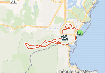

Length
8.5 km

Max alt
158 m

Uphill gradient
274 m
Km-Effort
12.2 km

Min alt
0 m

Downhill gradient
276 m
Boucle
No
Creation date :
2023-01-22 08:07:29.0
Updated on :
2023-01-22 11:33:13.219
3h25
Difficulty : Very easy

FREE GPS app for hiking
 SityTrail
IGN / Geographical institutes
SityTrail Plus
The world is yours!
About
Trail Walking of 8.5 km to be discovered at Provence-Alpes-Côte d'Azur, Maritime Alps, Mandelieu-la-Napoule. This trail is proposed by Arnaud Stévenard.
Positioning
Country:
France
Region :
Provence-Alpes-Côte d'Azur
Department/Province :
Maritime Alps
Municipality :
Mandelieu-la-Napoule
Location:
Unknown
Start:(Dec)
Start:(UTM)
333629 ; 4820591 (32T) N.
Comments