


Aspremont: Mont Cima

jlrayon
User
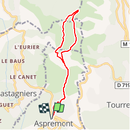

Length
7.4 km

Max alt
862 m

Uphill gradient
469 m
Km-Effort
13.6 km

Min alt
501 m

Downhill gradient
469 m
Boucle
Yes
Creation date :
2014-12-10 00:00:00.0
Updated on :
2014-12-10 00:00:00.0
2h53
Difficulty : Easy

FREE GPS app for hiking
 SityTrail
IGN / Geographical institutes
SityTrail Plus
The world is yours!
About
Trail Walking of 7.4 km to be discovered at Provence-Alpes-Côte d'Azur, Maritime Alps, Aspremont. This trail is proposed by jlrayon.
Description
Mont Cima au départ d'Aspremont par le GR5
Positioning
Country:
France
Region :
Provence-Alpes-Côte d'Azur
Department/Province :
Maritime Alps
Municipality :
Aspremont
Location:
Unknown
Start:(Dec)
Start:(UTM)
358666 ; 4849421 (32T) N.
Comments
un peu difficile pour des débutants