


Montaveilla

aldaus
User
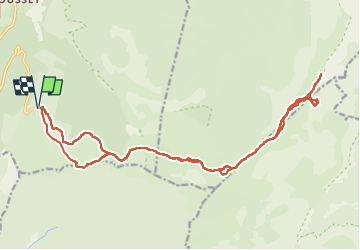

Length
23 km

Max alt
1966 m

Uphill gradient
984 m
Km-Effort
36 km

Min alt
1401 m

Downhill gradient
984 m
Boucle
Yes
Creation date :
2023-01-25 07:49:07.692
Updated on :
2023-01-25 14:35:31.548
6h10
Difficulty : Medium

FREE GPS app for hiking
 SityTrail
IGN / Geographical institutes
SityTrail Plus
The world is yours!
About
Trail Touring skiing of 23 km to be discovered at Auvergne-Rhône-Alpes, Drôme, Saint-Agnan-en-Vercors. This trail is proposed by aldaus.
Positioning
Country:
France
Region :
Auvergne-Rhône-Alpes
Department/Province :
Drôme
Municipality :
Saint-Agnan-en-Vercors
Location:
Unknown
Start:(Dec)
Start:(UTM)
691559 ; 4968302 (31T) N.
Comments