


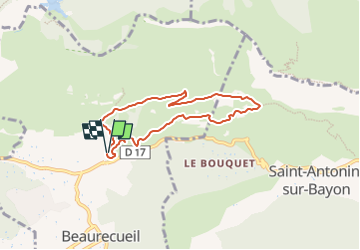
2023-01-25_18h09m08_randonnee-1130384-les-harmelins-et-les-ruines-du-trou

ego
User


2h10
Difficulty : Medium

FREE GPS app for hiking
 SityTrail
IGN / Geographical institutes
SityTrail Plus
The world is yours!
About
Trail Walking of 6.6 km to be discovered at Provence-Alpes-Côte d'Azur, Bouches-du-Rhône, Beaurecueil. This trail is proposed by ego .
Description
départ depuis le parking de l'Aurigon (parking de Roques-Hautes ) se fait à partir de la route départementale D 17 entre Le Tholonet et Saint-Antonin de Bayon.
belles vues sur la St Victoire passage au " refuge" Cézanne, puis au hameau perdu du Trou, belle calade entre la ruine et les reste de la chapelle
Positioning
Comments