


remisch

bohynm
User
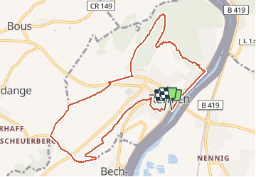

Length
9.7 km

Max alt
259 m

Uphill gradient
177 m
Km-Effort
12.1 km

Min alt
139 m

Downhill gradient
180 m
Boucle
Yes
Creation date :
2014-12-10 00:00:00.0
Updated on :
2014-12-10 00:00:00.0
2h23
Difficulty : Easy

FREE GPS app for hiking
 SityTrail
IGN / Geographical institutes
SityTrail Plus
The world is yours!
About
Trail Walking of 9.7 km to be discovered at Unknown, Canton Remich, Remich. This trail is proposed by bohynm.
Photos


Positioning
Country:
Luxembourg
Region :
Unknown
Department/Province :
Canton Remich
Municipality :
Remich
Location:
Unknown
Start:(Dec)
Start:(UTM)
309486 ; 5491094 (32U) N.
Comments
un guide très intéressant...