


les hauts de galande

ninia
User
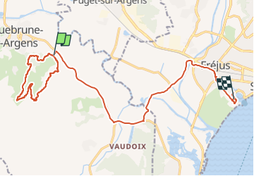

Length
21 km

Max alt
198 m

Uphill gradient
287 m
Km-Effort
25 km

Min alt
1 m

Downhill gradient
296 m
Boucle
No
Creation date :
2023-01-26 07:41:16.216
Updated on :
2023-01-26 11:13:09.365
3h00
Difficulty : Medium

FREE GPS app for hiking
 SityTrail
IGN / Geographical institutes
SityTrail Plus
The world is yours!
About
Trail Walking of 21 km to be discovered at Provence-Alpes-Côte d'Azur, Var, Roquebrune-sur-Argens. This trail is proposed by ninia.
Positioning
Country:
France
Region :
Provence-Alpes-Côte d'Azur
Department/Province :
Var
Municipality :
Roquebrune-sur-Argens
Location:
Unknown
Start:(Dec)
Start:(UTM)
310418 ; 4811960 (32T) N.
Comments