


condondorcet

marissou
User

Length
21 km

Max alt
856 m

Uphill gradient
718 m
Km-Effort
31 km

Min alt
341 m

Downhill gradient
719 m
Boucle
Yes
Creation date :
2023-01-26 07:58:58.671
Updated on :
2023-01-26 14:55:22.582
5h29
Difficulty : Easy

FREE GPS app for hiking
 SityTrail
IGN / Geographical institutes
SityTrail Plus
The world is yours!
About
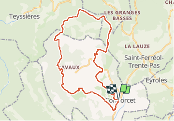
Trail Walking of 21 km to be discovered at Auvergne-Rhône-Alpes, Drôme, Condorcet. This trail is proposed by marissou.
Positioning
Country:
France
Region :
Auvergne-Rhône-Alpes
Department/Province :
Drôme
Municipality :
Condorcet
Location:
Unknown
Start:(Dec)
Start:(UTM)
675107 ; 4919447 (31T) N.
Comments